Hello everyone and thanks for stopping by the blog on this hot hot Friday! I want to start out by saying London has set a record high yesterday as did so many other cities. Mount Sterling set a record of 103 degrees, Barbourville and Monticello hit 101 degrees, Jackson hit 100, London hit 99, and Mount Vernon hit 98 degrees! Most of these temperatures got hotter than other summer months! Wow!
Today temperatures have risen even higher! Some temperatures have hit over 105 degrees! I do know that currently in London it's 104 degrees. I stepped outside for a moment and I felt like a pizza in the oven! haha anyways these temperatures looks to hang around through Sunday and there is a HEAT ADVISORY IN EFFECT UNTILL 12AM SUNDAY FOR THE ENTIRE STATE OF KENTUCKY. TEMPERATURES CAN REACH UP TO 105 DEGREES WITH HEAT INDICIES NEARING 110 DEGREES!
How are we getting this heat? Well we have a huge ridge of high pressure engulfing most of the country and the ridge is so powerfull it isn't letting any of these weak cold fronts pass by and sweep through our area. Location just to our west and southwest have temperatures nearing 110 degrees. Yes, I said it and that is actual air temperatures with heat indicies hitting 115 degrees and higher!
The positive side of the heatwave is that we have a chance of storms up to your 4th of July. Those chances are few and far between but at this point we'll take whatever chance we can get! I'll be following our rain chances in the coming days and tomorrow we look to have a 30% chance of some thunderstorms. A storm or two would really knock off those temperatures a few degrees.
Little relief of the temperatures in our future, by this time next week temperatures will still be in the 90s but they will be in the low to mid 90s. I would rather see a 90 degree temperature than a 100 degree temperature any day. I'll have more updates as needed and as anything comes up. In the mean time do a rain dance or something for us! ;) Have a great day everyone and take care! :)
Friday, June 29, 2012
Wednesday, June 27, 2012
Record Heatwave!
Hello everyone and welcome back to the blog! There isn't much to talk about in the weather world besides how hot we're going to get this week! Starting tomorrow actually! We're talking about record heat and temperatures hitting the 100 degree mark and above!
No heat advisorys, watches, or warnings have been issued for our area yet. I expect that to change soon as tomorrow we could be flirting with 100 degrees for your high temperatures. The hottest day looks to be either Friday or Saturday and by looking at some latest models some show temperatures could reach 105 degrees here in the southern and southeastern parts of the state.
I cannot stress enough how important it is to stay out of the heat. These temperatures are nothing short of unbearable. Even if you are not in the heat drink plenty of water to stay cool! There is a red flag warning that is in effect for much of the state due to low humidity levels and gusty winds and not to mention how dry the ground is. Speaking of a dry ground I promised you all with the new updated drought monitor map when it came out and here it is:

Thats a moderate drought now in parts of eastern Kentucky. Most of the state is in some kind of a drought at the moment. Western Kentucky is well into an extreme drought and all we can do now is hope for some rain.
I wanted to give you all a 7 day forecast to show how long this heatwave hangs around.
Tomorrow high 102 0% chance of rain
Friday high 105 0% chance of rain
Saturday high 104 10% chance of rain
Sunday high 103 10% chance of rain
Monday high 100 10% chance of rain
Tuesday high 100 10% chance of rain
Wednesday high 96 20% chance of rain.
Ouch! Hardly any chance of rain in sight! I'll have more on the heatwave with quick updates on facebook! Have a great day everyone! Stay safe and take care! :)
Monday, June 25, 2012
The Heat Is On
Hello everyone and welcome to the blog on this warm and muggy day here in southeastern Kentucky. Tomorrow we'll get a brief brake from the heat but if any of you seen the facebook statuses I've sent out this morning you know whats ahead for us and it's not looking good.
Here lately temperatures have been a bit above average and thats about to chance for late in the week. Thursday into Friday looks to be the hottest days by far of the young Summer season. Forecast high temperatures are showing 100 degrees for the high on Thursday and 101 for the high on Friday. Wow. The hottest days of the year is coming and maybe some tweaks in the forecast and I hope thats the case. We sure don't want those 100 degree temperatures in here. Some models have the heavwave ending Sunday and other have it going on with highs near 100.
On another note Tropical Storm Debby has been in the Gulf of Mexico for quite a while now and no model can agree on it's path, but with it being so close to Florida I believe now that it will come on shore on Florida. Here's the latest path:
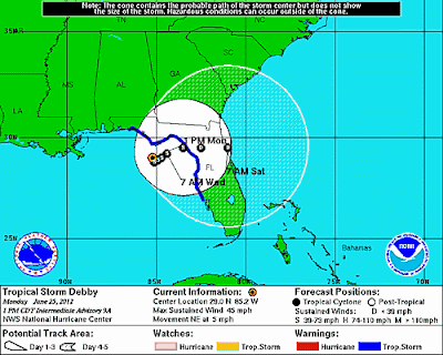
Alot of things are still uncertain with Tropical Storm Debby at the moment. As you can tell, the end of the path is when it comes back off shore of Floridaand that looks to be on Saturday. Debby is one slow moving system and is dumping alot of rain on Florida not to mention 12 Tornadoes have been reported yesterday in Florida I believe that number is right correct me if I'm wrong.
Anyways the new drought index comes out tomorrow and theres a chance the whole state could be in a section of "abnormally dry" after that it becomes a slight drought. Western Kentucky is well into a severe drought and when the new index comes in I will post it on here.
Have a great Monday everyone and take care! :)
Tuesday, June 19, 2012
Mini Heat Wave Continues
Hello everyone and welcome to the blog! We have a mini heat wave that continues to hang around here and will do so untill Friday when we get a bit of relief in here but that will be short lived. Today temperatures will generally run in the 90-95 degree range with some light winds.
Tomorrow temperatures will run a bit warmer but generally in the 90-95 degree range again. The western parts of the state could see temperatures hit above 95 degrees. The humidity will still be with us making for a very muggy day. A cold front will move in late on the day Thursday into the day on Friday and will be some relief in the way of some showers and thunderstorms. Temperatures for the first half of the weekend will hold in the mid and upper 80s for highs.
Sunday temperatures soar back up into the mid 90s for most locations but that could spark off some thunderstorms, especally the further southeast you live. Monday the heat wave snaps as a trough moves over the Great Lakes and that will keep us in the chance for thunderstorms and it is looks more and more each day like a severe weather producer.
As you can probably tell, cracks are starting to form in the ground and it also starts to get very hard. We are a bit on the dry saide and any rain would be nice and would help as well. We don't want anyones mater plants to dry up now do we? ;)
Have a great day everyone and take care! :)
Monday, June 18, 2012
I'm Back!
Hello everyone and welcome back to the blog! I've had the blog on hold for about a month now and many of you know the reason why but for those whom don't, I was in a wreck and broke my femur. I was driving and hydroplaned and hit a big Oak tree. My best friend was with me and thank the lord we're okay.
Anyways today makes one month since the wreck, and I've been spending alot of time recovering and l me tell you first hand it isn't easy! Now I am able to make posts once again and so with that let's get to the weather!
Temperatures the next several days will top out at or above the 90 degree mark and the humidity will make it feel even hotter! Tomorrow most locations will be right around 90 degrees with the mid and upper 90s being very common across western Kentucky! Ouch thats hot! An isolated thunderstorm could pop up especally with the humidity being as high.
Thursday into Friday we'll see a cold front swing through and it will try to know temperatures down a few degrees and bring some rain chances our way. Speaking of rain the state is actually is pretty dry in some spots. Here's a look at the drought monitor:
 Moderate drought in the west and some slight drought spots in south central and eastern Kentucky. Any rain will help! Especally in the west!
I'm looking at a shot of cool air trying to make its way back in for the start of the week and I'm also keeping an eye on the Gulf of Mexico for a threat of some tropical activity ;)
Thanks for being patient in my recovery process. I'm continuing to heal and all support is great! Have an awesome night everyone and take care! :)
Anyways today makes one month since the wreck, and I've been spending alot of time recovering and l me tell you first hand it isn't easy! Now I am able to make posts once again and so with that let's get to the weather!
Temperatures the next several days will top out at or above the 90 degree mark and the humidity will make it feel even hotter! Tomorrow most locations will be right around 90 degrees with the mid and upper 90s being very common across western Kentucky! Ouch thats hot! An isolated thunderstorm could pop up especally with the humidity being as high.
Thursday into Friday we'll see a cold front swing through and it will try to know temperatures down a few degrees and bring some rain chances our way. Speaking of rain the state is actually is pretty dry in some spots. Here's a look at the drought monitor:

I'm looking at a shot of cool air trying to make its way back in for the start of the week and I'm also keeping an eye on the Gulf of Mexico for a threat of some tropical activity ;)
Thanks for being patient in my recovery process. I'm continuing to heal and all support is great! Have an awesome night everyone and take care! :)
Subscribe to:
Posts (Atom)