Good late afternoon everyone we're currently in the middle of an early spring winter storm. Hints the title of this post right? ;p Anyways, let's get to the details on this storm. Temperatures will hover around freezing until the sun starts to set then will dip down into the 20s as snow starts to accumulate once again on area roadways. Travel conditions after sundown will be hazardous.
I expect an additional 1-2 inches for most areas after the sun goes down. Areas above 1500 feet could see an additional 2-4 inches. I have been getting alot on questions on my facebook concerning the chances for school tomorrow for several areas. I do think conditions will get very rough tonight into tomorrow as snow showers and flurries will continue through late morning tomorrow. I do expect widespread school cancelations and delays.
On the bright side, Temperatures come up just in time for the weekend. Friday highs hear 52 degrees, saturday high 55, and finally Sunday a high temperature of 58 degrees. Is spring finally here? I'll touch up on that later on but first we got to get this cold and snow out of here.
Have a great evening everyone, be safe and take care! :)
Monday, March 25, 2013
Wednesday, March 20, 2013
Happy First Day of Spring/ Another Announcement
Hello everyone and welcome back to the blog! Today as many know is the first day of spring! March 20th 2013. Nobody is more excited to see this on the calendar than this weather dude. ;) If you've seen any of my posts last night in facebook you could tell that I'm very anxious for spring weather.
Last night I also made the post that I'm starting a fundraiser to hire a search and rescue team to find spring! Still, I'm not seeing any sign of spring at all. Noth within the next week or two. Yeah I know, I'm getting pretty tired of being the guy that brings all the bad news. Anyways Let's get to the weeks forecast.
Today, high temperatures will range from the upper 40s to low 50s here in southern Kentucky. Temperatures will continue to range in the upper 40s and low 50s for the rest of the week. Kepp in mind that average high temperatures for this time of year is pushing 60 degrees or more here in southern Kentucky. This weekend we'll have the potential for a big storm to develop and bring alot of rain to the area on Sunday then switch over to a mix then snow with the possibility of a light accumulation.
That system will then bring down another re-enforcing shot of cold air in and yet another snow chance for the middle of next week. Like I said above.. I'm not seeing any sign of spring in the next week or two... :(
Anyways, I have decided to do something different with the way I get the weather information out there. With my name growing and predicting the weather is becoming a bigger demand for folks around here, It's getting alot harder for me to gather local storm reports from around the nearby areas. This is where you come in, If any of you have pictures or any reports of what the weather is doing where you live, please send them to me! I would love to have them. With weather events, especally thunderstorms you're set of eyes are more usefull than radar images as you can see exactly whats happening at the surface as the radars cannot see that. I've never asked for any or your help but I am now. If you can help me with this, we will INCREASE our chances of SAVING LIVES and REDUCING any weather related INJURIES.
Thank all of you for reading, have a great Wednesday everyone and take care! :)
Sunday, March 3, 2013
Next System/ A Taste Of Spring
Hello everyone and good evening to you. I hope everyone got the chance to read the last post "Flashback: March 2nd 2012" I worked very hard on that one and I've got some good feedback on it so far. Anyways let's talk about the next storm system thats moving in and our chances of seeing spring in our near future.
The next system is set to impact us Tuesday into Wednesday with it coming form the north and west then it will give way to a developing system that will move through the Carolina states up the east coast. We're likely to start out as a very cold rain then change over to a period of moderate to heavy snows Tuesday night into early Wednesday morning. Now, this is where things get tricky as some models keep the heaviest of snows just east of here into Virginia yet others such as the folks from the HPC says the best shot for accumulating snows is here in southern, southeastern, and eastern Kentucky. As you can see below:
 Thats an 80-95% chance for at least one inch of snow in eastern Kentucky. Now clearly as you can see that locations such as London, Somerset, to Lexington has an 80% chance. Ashland and Morehead I would have to say 90%.
Here's what the GFS shows early Wednesday morning as widespread snow showers take over eastern Kentucky:
 As of now I would say accumulations of 1-2 inches is a shot more much of the area but I would say 1 inch or less is more realistic.
Enough snow talk, where's spring?! Well I have good news and bad news. Bad news first. I am seeing spring like temperature sin the near future but it's only a brief taste of spring. The good news is that this taste of spring will come just in time for the weekend (starting March 8th) where temperatures are likely to hit 60 degrees for much of the state with temperatures pushing 65 degrees very likely in the southern areas.
Although I do not see any sign of full fledged spring in the near future. I see Old Man Winter having a grip on us for the next 2-3 weeks at the least. Have a great night everyone and take care! :)
The next system is set to impact us Tuesday into Wednesday with it coming form the north and west then it will give way to a developing system that will move through the Carolina states up the east coast. We're likely to start out as a very cold rain then change over to a period of moderate to heavy snows Tuesday night into early Wednesday morning. Now, this is where things get tricky as some models keep the heaviest of snows just east of here into Virginia yet others such as the folks from the HPC says the best shot for accumulating snows is here in southern, southeastern, and eastern Kentucky. As you can see below:

Here's what the GFS shows early Wednesday morning as widespread snow showers take over eastern Kentucky:

Enough snow talk, where's spring?! Well I have good news and bad news. Bad news first. I am seeing spring like temperature sin the near future but it's only a brief taste of spring. The good news is that this taste of spring will come just in time for the weekend (starting March 8th) where temperatures are likely to hit 60 degrees for much of the state with temperatures pushing 65 degrees very likely in the southern areas.
Although I do not see any sign of full fledged spring in the near future. I see Old Man Winter having a grip on us for the next 2-3 weeks at the least. Have a great night everyone and take care! :)
Saturday, March 2, 2013
Flashback: March 2nd 2012
Hello everyone and welcome back to the blog. This post is only to talk a look back at the historic tornado outbreak of March 2nd 2012. In this post I will share my feelings, actions, and thoughts from that day. Also I will talk about some senarios that did happen and what could have happened.
I want to start with showing you these SPC products. These images play a big role in a storm chasers agenda and where to chase. Why am I telling you this? Because two things. One, storm chasers go after tornadoes. Two, storm chasers never come to Kentucky to chase because all the trees and mountains making it hard to see the sky which plays a HUGE rold when storm chasing. It's very dangerous to chase in Kentucky, but on this day the biggest and most well known chasers were in Kentucky.
The first image is a categorical graphic. There are three categories. Slight, Moderate, and High. Now before you look at the image please note that a HIGH risk is only issued a few times a year. Actually you'd be lucky to see it issued twice in one years time. It's very rare.
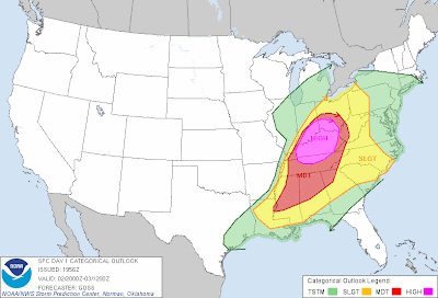 Thats a HIGH risk area for over 75% of the state. Here's a look the the chances for tornadoes that day:
 Don't look at this image and think, "oh, 30% that isn't too bad." In fact a 30% hatched area is very bad. Thats a high risk for long lived, long track, massive tornadoes. Even the 10-15% area is an elevated risk.
I for one had seen this outbreak coming for days ahead of time. This day was actually a break-through day for me. Knowing that during the day of this severe weather event was ongoing was frustrating for me. I tried to get the word out and people failed to listen, instead people went on making fun of the posts I made and posting pictures of a clear sky saying "look at this tornado". Yes, I wish I was wrong, but sadily I wasn't.
The image below was taken during the day of March 2nd.
 This picture was taken by Tiffany Stanfield, you can just see how calm conditions were leading up to the events that took place later on that day. Thank you Tiffany for the picture!
Alot of people will look at conditions outside and see exactly what you see in the picture above and think "well it looks good outside so I don't think anything will happen." DON'T BE FOOLED! When skies looks clear, nice and warm it's actually doing more harm than good. The more sun you see means the more unstable the air is causing the instability levels to go through the roof. That makes an elevated risk for severe weather.
Before these storms moved in I was chasing smaller cells myself. The less severe ones just trying to get some pictures. I had a weather radio on me and I heard a tornado warning being issed. Pannic quickly set in and I took off towards my home as fast as I could. I knew that this point I could be more of a value of getting the word out and any new information rather than getting in the way of any damage and risking my own life.
I then got word of several injuries and deaths as well. This bothered me alot more than words can describe. The fact that not many people took this day very seriously was aggrivating but I can understand why many of you didn't take it too seriously because this is the hills of eastern Kentucky... Tornadoes just doesn't happen over here. Thats the bottom line.
Several things have to come together in order to produce a tornado outbreak of this magnitude. Basically you can say these combinations came together to form nothing short of "prefect conditions" for tornadoes. Yes, one or two of the basic elements can be missing and tornadoes still form but with that being said the tornadoes would be relatively weak and last nothing more than 5 minutes at the most. All of those elements were present on March 2nd, thats what made it to be such a historical day in weather.
As weather events as horrible as this one happens, Meteorologists and Scientists work to better understand thunderstorms and why some produce tornadoes and others do not. They also work to better track tornadoes and predict them as well. With each significant weather event that happens this group of men and women learn more and more and eventually we will be able to predict tornadoes efficently.
Tornadoes can happen anywhere. Hills, cities, bodies of water have no protection from tornadoes. A tornado once tracked up a hill in LA and damaged the famous "Hollywood" sign. Tornadoes have been known to start off a "water spouts" and come onto land causing destruction. Joplin Missouri is one of the latest big cities to be hit by a tornado. In the Joplin tornado, at least 65% of the town was rubble. No body of water, city, or hill is completely safe from a tornado.
I ask of only one thing from all of you as we get closer and closer to the severe weather season of 2013. Please know what to do in weatehr situations, and be more prepared. sadily, sometimes it takes a disaster such as the March 2nd outbreak to realize how prone to certain weather events we really are. It's always good to know where to go and what to do when a tornado strikes.
Thanks for reading and please stay safe this severe weather season. I will keep you up to date through out the year like always. Take care everyone.
I want to start with showing you these SPC products. These images play a big role in a storm chasers agenda and where to chase. Why am I telling you this? Because two things. One, storm chasers go after tornadoes. Two, storm chasers never come to Kentucky to chase because all the trees and mountains making it hard to see the sky which plays a HUGE rold when storm chasing. It's very dangerous to chase in Kentucky, but on this day the biggest and most well known chasers were in Kentucky.
The first image is a categorical graphic. There are three categories. Slight, Moderate, and High. Now before you look at the image please note that a HIGH risk is only issued a few times a year. Actually you'd be lucky to see it issued twice in one years time. It's very rare.


I for one had seen this outbreak coming for days ahead of time. This day was actually a break-through day for me. Knowing that during the day of this severe weather event was ongoing was frustrating for me. I tried to get the word out and people failed to listen, instead people went on making fun of the posts I made and posting pictures of a clear sky saying "look at this tornado". Yes, I wish I was wrong, but sadily I wasn't.
The image below was taken during the day of March 2nd.

Alot of people will look at conditions outside and see exactly what you see in the picture above and think "well it looks good outside so I don't think anything will happen." DON'T BE FOOLED! When skies looks clear, nice and warm it's actually doing more harm than good. The more sun you see means the more unstable the air is causing the instability levels to go through the roof. That makes an elevated risk for severe weather.
Before these storms moved in I was chasing smaller cells myself. The less severe ones just trying to get some pictures. I had a weather radio on me and I heard a tornado warning being issed. Pannic quickly set in and I took off towards my home as fast as I could. I knew that this point I could be more of a value of getting the word out and any new information rather than getting in the way of any damage and risking my own life.
I then got word of several injuries and deaths as well. This bothered me alot more than words can describe. The fact that not many people took this day very seriously was aggrivating but I can understand why many of you didn't take it too seriously because this is the hills of eastern Kentucky... Tornadoes just doesn't happen over here. Thats the bottom line.
Several things have to come together in order to produce a tornado outbreak of this magnitude. Basically you can say these combinations came together to form nothing short of "prefect conditions" for tornadoes. Yes, one or two of the basic elements can be missing and tornadoes still form but with that being said the tornadoes would be relatively weak and last nothing more than 5 minutes at the most. All of those elements were present on March 2nd, thats what made it to be such a historical day in weather.
As weather events as horrible as this one happens, Meteorologists and Scientists work to better understand thunderstorms and why some produce tornadoes and others do not. They also work to better track tornadoes and predict them as well. With each significant weather event that happens this group of men and women learn more and more and eventually we will be able to predict tornadoes efficently.
Tornadoes can happen anywhere. Hills, cities, bodies of water have no protection from tornadoes. A tornado once tracked up a hill in LA and damaged the famous "Hollywood" sign. Tornadoes have been known to start off a "water spouts" and come onto land causing destruction. Joplin Missouri is one of the latest big cities to be hit by a tornado. In the Joplin tornado, at least 65% of the town was rubble. No body of water, city, or hill is completely safe from a tornado.
I ask of only one thing from all of you as we get closer and closer to the severe weather season of 2013. Please know what to do in weatehr situations, and be more prepared. sadily, sometimes it takes a disaster such as the March 2nd outbreak to realize how prone to certain weather events we really are. It's always good to know where to go and what to do when a tornado strikes.
Thanks for reading and please stay safe this severe weather season. I will keep you up to date through out the year like always. Take care everyone.
Subscribe to:
Posts (Atom)