In the picture below you'll see a few tracks with different colors. As you can tell this was all done from scratch with the ol' handy dandy Paint accessory on my laptop. Hey don't judge okay? ;p anyways, here's the map and take a look for yourself. I'll break everything down for you below the picture:
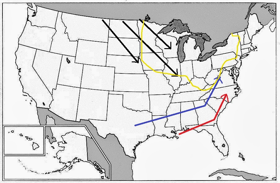
Okay as you can see I have four different colors so that's four different tracks to cover.
Track #1 Black: The lines you see in black coming out of Canada is one of the most common paths you see producing snow during the winter months and sometimes as early as the Fall months. This path is commonly known as an 'Alberta Clipper'. Meaning that this is a clipper system further meaning it moves quick and lacks a lot of moisture, Alberta means that's where it comes from, Alberta Canada. Typically when a clipper system move into our area out of Alberta it means very cold air is also on the way. With an 'Alberta Clipper' around here you'll be lucky to pick up more than 3-4 inches of snow out of it.
Track #2 Yellow: Anything north of the yellow line are areas that commonly see and experience the next system like way to see snow. This one is called 'Lake Effect Snows' The Great Lakes produce this 'Lake Effect Snow' when cold air moves over the warmer lakes and produces snow. This snow can dump upwards of a foot for areas nearby the lakes. What about this far down into Kentucky? Sometimes we can see a couple of inches probably 4 at the max and that's on a very good day.
Track #3 Blue: This track is also very common during winter. It brings low pressure systems out of Texas and scooting them eastward to Georgia before turning northeast through South Carolina, Tennessee, and Virginia. This normally starts off as rain and changes over to snow. Sometimes the change over is so rapid that you don't even see any mixed precipitation. In this scenario, everything to the north and west of the low is usually all snow. If your just to the north of the low but very close to where the low is setting up you'll probably see a cold rain until the system moves off to your east and northeast and allows cold air to wrap around the backside and change rain over to snow. This track typically puts down anywhere up to 4 inches with local spots picking up a touch more on a good day. If a system tracks about 100 miles further to the south of the blue line, you can go from 2-4 inches to 6"+.
Track #4 Red: This one is the big one, the 'Big Mamma'. When storms form just off the coast into the Gulf of Mexico like this one it allows abundant moisture to gather and move onshore. If cold air is present in the Ohio and Tennessee Valleys as this storm moves into Georgia and starts to move northeast snow can be seen falling as south as Atlanta, Georgia. Well it happened in the 'Superstorm of 1993' anyways. As this storm moves north, (in which the best track may be further north since I done the map myself) with the (hopefully) cold air that is present all snow would fall in the Tennessee and southern Ohio Valley areas (southern and south central Kentucky). Record snows could fall like back in 1978 and 1993 where upwards of 20 inches of snow fell (22 inches with localized high amounts in 1993 in London to be exact). That kind of snowfall would shutdown entire towns for days and knock out power to millions of people. It would be a snowstorm of historic proportions like 1993 and 1978 was. Making Track #4 Red, the best path for snowstorms in southern Kentucky.
Hope you all enjoyed this post and I also hope your ready for the winter season ahead. As a weather guy, my gut tells me and gives me bad feelings about the winter that's upcoming. Like always I'll post more information and updates as it becomes available on my new facebook page Clayton Banks SEKYWeather. Have a great evening everyone and take care!
