Contact Me at sekywx2023@gmail.com

Name

Email *

Message *

Tuesday, January 31, 2012

February Turns Cold... And Snowy???

Hello everyone and welcome to the blog! We're wraping up another great day of amazing weather with temperatures well into the 60s for highs for many locations with plenty of sunshine to be had as well. Tomorrow things turn a bit rainy but temperatures will hold strong in the 50s all the way towards your Friday. Big changes are in store for the weekend and beyond so let's get to it.

This weekends storm is looking alot more better in terms as in knowing it is going to happen. The models are all saying this thing will happen but of course the typical arguements between them on when and where and what time exactly this will happen. That will be more clear as we get closer to the weekend.

The models are talking about a potential Tornado Outbreak to our west in Missouri and Arkansas. With a snow storm to the north of those areas.

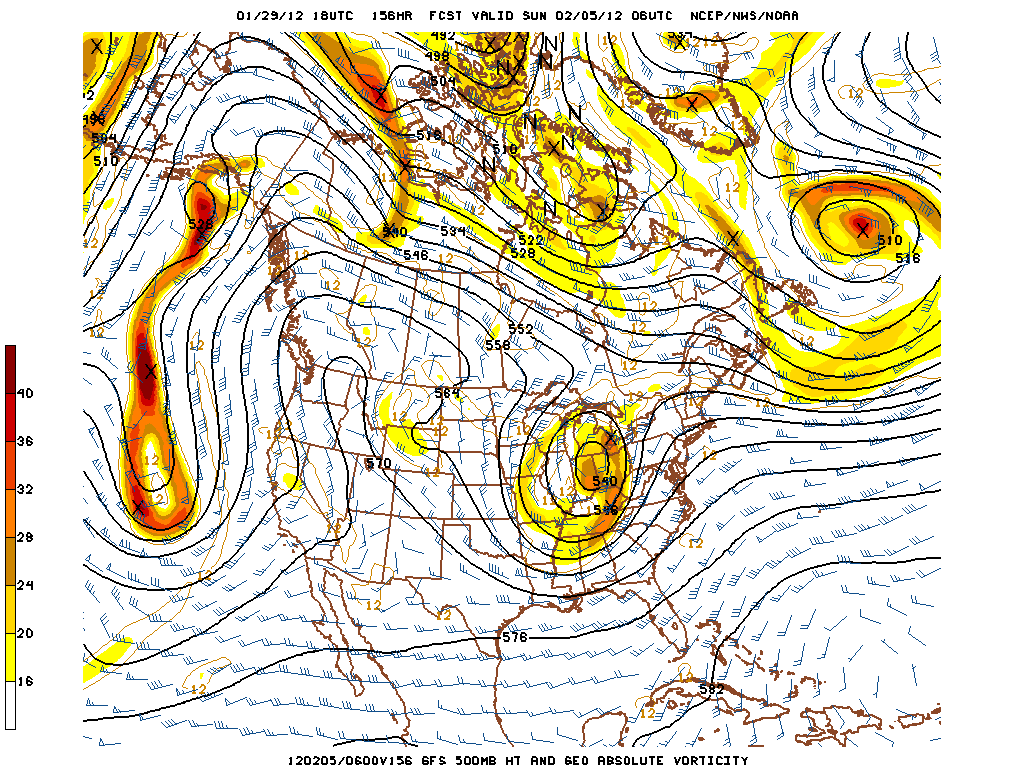
Here's something I wanted to point out... Which is the cold thats in store for the month of February. Take a look at this picture real good and then I'll walk you all through what it is trying to say...
Okay you see the blue color? That means colder than normal temperatures are expected for those days listed above the picture. The darker the blue, is the colder the temperatures are expected to get. I'm not saying that dark blue in Mexico is making them colder than us, but I am saying that it means it will make them colder than their normal temperatures for that time of the year. As for the green and yellow? You guessed it right, they mean warmer than normal temperatures are expected for that area. With the yellow being the warmest of the two.

That above is all part of a big ridge of high pressure creating a deep trough that will sweep through our area for the first half of the month of February... At least :).

I have a feeling that I'm going to be one busy weather dude during this two week period. But we shall figure out for sure as time goes by and we get closer.

Have a great night everyone and be safe! More updates as needed! :)

Short Term

Hello everyone and good Tuesday Morning to you all as well. Here's alook at our short term weather which most of you will love.

Today: sunny with some clouds in the sky. High temperatures in the low to even a mid 60 or two out there. Tonight: lows in the upper 40s to low 50s with a 50% chance of rain showers.

Tomorrow: cloudy with a good chance at some more rain. Highs in the upper 50s with a few low 60s very possible as well. 70% chance of rain showers. Tomorrow night: lows in the low to mid 40s with a 50% chance of rain showers.

Thursday: sun and clouds. High temperatures in the upper 50s.
Friday: sun and clouds. High temperatures in the upper 50s some locations may hit 60.

Thats a good looking forecast if you ask me. Especally with this being in early February!!! :)

I'll have more on the potential big cutoff low pressure system for this weekend later on in the day today. Right now the models is arguing with the track and timing of the system which was to be expected because we're still almost a whole week out.

Have a great Tuesday and take care everyone! :)

Monday, January 30, 2012

Monday Night Update

Good Monday evening everyone and as I said earlier today I would get a update in on the blog sometime later. I have found out it is best to do it sooner than later because I may not end up will all things needed for a good update.

This update will be mainly for the upcoming storm that looks to impact our area later on in the weekend than I first initally thought. Before we get to all of that I want to take about the awesome weather we've been having lately.

I know that your thinking mid to upper 50s in late January is a rare gift right? Well it actually happens all the time. What's in store for tomorrow? Can you say low to mid 60s?!? Yeah it's going to happen for us with plenty of sun and very few clouds. That is a rare treat for the heart of the winter season.

What about Wednesday? Can we press our luck for another warm day? The answer is yes, but you'll have to deal with the rain coming in as well. The rain looks to hold temperatures in check into the mid 50s.

Now to the topic that everyone wants to hear about. The potential big weekend storm. This thing seems to slow down a little bit. Late weekend looks to be when it will impact our area. I also want you all to take a look at this from the GFS model...
Thats a pretty deep system working it's way into here....
Look at the next picture of the GFS model. This one should show a bit more in the way of how the precip looks...Yeap, things are looking good for a big storm late next weekend :)

More updates tomorrow and as needed. Have a great night everyone ans take care! :)

Sunday, January 29, 2012

Sunday Evening Model Thoughts

Hello everyone and good Sunday evening to you all. I hope you all had a great weekend and as I promised earlier here is a full update on the potential weekend storm and some thoughts on the models and what they all point to.

Here's a look at the GFS model...
Look at the space between the system off the west coast and the system over the Ohio Valley. Now look at how those lines bend. Thats showing a trough and the jet stream diving south over the midwest. This is on Early Sunday morning. Although we're still one whole week out this is something to keep in mind because if this system does take this track we're looking at a good shot at some winter weather.

Here's another look on the GFS model. Like I said above if the system does take on this track we'll likely see a rain to snow change.

Last but not least I have the European model to show to you all...

I personally like this one. The European model has been way more consistent than the GFS models over the past year. Plus the analog years are talking about this as well.

Now back to the short term. Temperatures will begin to spike up into the 50s by mid-week just to bring some more unwanted rains our way.

During the weekend is when that possible winter event will take place for the eastern half of the country. With that being said we cannot say how much snow or who will see it yet, because we just don't know and only time will tell us as we get closer to that.

More updates as needed. Have a great night and an even better start to your Monday. Be safe and take care! :)

Big Weekend Storm?

Good Sunday to you all out there and I hope your having a great one. This update is about that big weekend storm system that looks to affect the eastern half of the country just in time for the start to February. After looking at some models we're possibly looking at a wintry pattern through the month of February.

Now according to the GFS model here's how the the weekend system looks to move in and how it looks to play out.
Now this shows a ridge of high pressure forcing the jet stream northward and when doing that it makes the jet stream take a big dive in the midwest and as you can see that orange over us shows a weather system and that show be the big one we we're talking about that may be our next snow maker :)

Have a great Sunday and take care! :)

Quick Update

Hello folks and good very early Sunday morning to you all. Later on in the morning hours we'll see a quick moving system sweep through here and bring a shot of colder air along with some snow showers and flurries. No accumulation expected.

Ahead of this front you may see temperatures rise a few degrees as along the front snow showers and snow flurries will fall and the best shot at seeing that is up in northern Kentucky. Some very light accumulations can be expected up there but nothing much either.

After today temperatures will rise back up and into the 50s my mid week! Sounds good to me, but late Tuesday into Wednesday is when the next rain maker moves into town.

To make a long story short here, this weekend a big cutoff low pressure looks to affect the eastern United States as a potential SNOW STORM. Will that affect us? Will we see any snow at all? Those are questions I hope to answer as the next few days rolls by as we know more. Yes, I know how our winter has been playing out and things aren't working in our favor for this storm to happen and bring us some snow but some models are indicating that this may be out best chance at seeing some snow so far this winter season :).

More updates to come like always! Have a great start to your Sunday and take care! :)

Friday, January 27, 2012

Weekend Clipper Systems

Hello everyone and good Friday afternoon to you all. Heavy rains swamped most of the state last night into the early morning hours this morning. We're watching two clipper systems to move in and affect our weather for the weekend. One on Saturday morning and the other on Sunday.

The Saturday clipper system looks to be mainly rain with a touch of snow behind it. If any accumulations happen they will be very light and will happen to the north of here. The Sunday clipper system will bring a mostly snow event, but accumulations look to be very light as well as they will happen north of here. a little dusting is possible here but the chances of that are very slim.

Looking ahead some models are talking about a potential big system to set up shop to the east of here and also as of now this are looking good for the wintry side to affect us but seeing how this winter has went so far the chances of this system affecting us aren't likely :/. Keep your hopes up because the chances are still there! All we need is some colder air and moisture then we're in business!

More updates as needed, have a great Friday and take care! :)

Thursday, January 26, 2012

Heavy Rains Tonight

Hello everyone and good Thursday afternoon to you all out there. Temperatures are starting out in the upper 50s to low 60s with rain in the area. Heavier rains will move in later this evening into tonight with an increased risk of flooding through the night. And for that a FLOOD WATCH IS IN EFFECT FOR MOST OF CENTRAL AND EASTERN KENTUCKY.

This thing for quite a bit of areas cound see as much as 1-3" of rain. The NAM model is showing a swath of haevy rains for central and western Kentucky with as much as 3 inches falling over there.

The rain will slowly get a move on out of here Friday with cold air once again moving back into place, it will not be all too cold like we've seen in the past but it has the chance for a quick mix to fall.

Colder air makes it's way in this weekend with highs on Sunday struggling to get out of the upper 20s to low 30s.

I'll have more updates as needed and quick updates on Twitter and Facebook. Have a great Thursday everyone and take care! :)

Tuesday, January 24, 2012

Warm Days To Continue

Hey folks and thanks for stopping by the blog on this Tuesday evening. I've had a rough few personal days but now everythings all sorted out and we are now back on track.

The thunderstorms the other night weakened alot just before they came rolling through the area. Temperatures continued to hang in the 50s. Today was a very nice day as well with the warm temperatures dominating the headlines, tomorrow into Thursday temperatures will stay in the mid and upper 50s and on Wednesday night the rain looks to move in.

Thursday the warmth stays in the area with temperatures in the upper 50s and even into the 60s. Rain will be the heaviest on this day with temperatures coming back down for highs in the 40s on Friday.

More updates as needed as always via Twitter and via Facebook! Have a great Tuesday night everyone! :)

Sunday, January 22, 2012

Severe Weather Update

Hello everyone and thanks for stopping by the blog! Here's another quick update on the severe weather situation. Night, winds will be coming out of the south and that will help keep temperatures into the 50s. Actually it will make our temperatures rise overnight into the mid and upper 50s and maybe even a 60 out there.

What these winds will do is they pick up moisture from the Gulf of Mexico and like I've been talking about over the last few days is the moisture from the Gulf of Mexico is always prime and juicy for severe thunderstorms.

As you read this the line of severe thunderstorms is moving through the Paducah area and are marching eastward. No tornado warnings have been issued there yet and I hope none have to be issued. There have been a few severe thunderstorm warnings that were/are issued but nothing any worse.

The main chances for severe weather is to the west and southwest of here, but that doesn't mean we're in the all clear.

I'll have updates via Twitter and via Facebook as needed, I can't protect you but I sure can let you know when and where severe weather may strike to help you take cover! :)
Have a great night and take care!

Tornado Watch!

Hey guys just a quick update to tell you the SPC has issued a TORNADO WATH FOR WESTERN KENTUCKY UNTILL 2AM CST/3AM EST. Tornadoes, damaging winds, and large hail are very possible with some storms.... Areas in Arkansas currently or already had LARGE VIOLENT TORNADOES ON THE GROUND.

I expect the watches to extend eastward into central Kentucky and even Eastern Kentucky late tonight into the early morning hours. As of right now it looks as if the front will be here between 7am and noon. But the storms will be a bit ahead of the front.

More updates as needed! Have a good night and take care.

Saturday, January 21, 2012

Severe Thunderstorms To Affect The Area Late Tomorrow

Hello everyone and good Saturday to you. Today has been cloudy and cold with most temperatures holding in the low to mid 30s with a few snowflakes and or drizzle falling at times. A BIG warm up is in store for tomorrow as well as some strong to severe thunderstorms.
Here's the SPC (Storm Prediction Center) Outlook for categorical chances for severe thunderstorms:
That may be upgraded in western Kentucky soon because they look to have a better risk of severe weather. Look at the Probabilistic chances and it will tell it all:

Thats a 30% hatched area and across the whole state the following is very possible... LARGE HAIL, DAMAGING WINDS, AND TORNADOES ARE ALL POSSIBLE SUNDAY EVENING INTO THE NIGHT AND EARLY MONDAY MORNING.

Some forecast models are calling for a tornado outbreak down in Dixie Alley. Alabama, Mississippi, and Georgia just to name a few. Cool-Season tornadoes IS just as DEADLY and DANGEROUS as any other tornadoes!

I will have another update up later tonight and as always through out the day tomorrow and into the night I will be updating as we go. Remember folks, most of my updates and most frequent updates are on Facebook. If possible send me a request and a message telling me your a follower from Twitter and I will make sure I accept your request.

Have a great night and take care! :)

What A Wild Day Of Weather.

Hello everyone and good late morning to you. I promised a full update last night and I was unable to deliver and I am sorry for that, I was busy tracking a line of strong and severe thunderstorms ahead of a front that produced several severe thunderstorm warnings and I also got reports in from some of you telling me penny sized hail was falling and in one area it fell was near the Hal Rogers Parkway just to the west of London, and that same cell produced some weak rotation with it as well.

This was certainly a wild day of weather across the bluegrass state. Icy conditions in northern Kentucky with temps around 30 and at the same time temps were well into the 50s with strong and severe thunderstorms rolling across southern and southeastern Kentucky. Today the cold are will eventually win the state and the cold conditions returning. How long will the cold stick around? Not very long, tomorrow warmer air will move back in from the Gulf of Mexico ahead of a potent Cold front. Like I've been saying the warm air from the Gulf of Mexico is always very juicy, and by that I mean prime for strong and severe storms to break out. That air from down south provides the instability needed for those strong and severe storms to crank up.

The storms are expected to move in as a squall line but there may be some seperate thunderstorm cells pop up ahead of the main line of storms and be pretty strong as well. The good thing about the storms coming in as a squall line is that it reduces the tornado chances, BUT! THAT DOES NOT MEAN THAT TORNADOES ARE NOT POSSIBLE!! Just throwing that one out there :)

Lately I've been updating my facebook more than twitter so if your a follower from twitter I highly suggest you follow my posts on facebook because I post on there more often. Just let me know that your a follower from twitter when you add me on facebook so I won't reject the request.

Have a great Saturday and more updates as needed with a full update WILL come your way tonight. Take care! :)

Friday, January 20, 2012

Updated Winter Weather Advisory...

Winter Weather Advisory remains in effect for the far northern counties in Kentucky and now has been extended to include a few counties to the south... Here is the valueable information needed for the advisory...

 Accumulations of around one tenth of ice and up to an inch of snow. Wintry mix and rain will change over to all freezing rain later this evening and then eventually to snow on the back side of the system in the morning hours.


Here's the updated Winter Weather Advisory map:

Like always updates later! Take care everyone! :)

Winter Weather Advisory...

Hello everyone and good afternoon to you as well. Just thought I'd bring this by you all as a bit of an update of what is going on just to our north today and tonight into the early morning hours tomorrow...

A Winter Weather Advisory is in effect for the northern most counties in Kentucky untill 11am est. Accumulations of around one tenth of ice and up to an inch of snow. Wintry mix and rain will change over to all freezing rain later this evening and then eventually to snow on the back side of the system in the morning hours.

Here's a look at the Advisory map:
Although that is not in effect for us but it is pretty impressive considering the fact that temperatures down here will be in the upper 40s to even low 50s this evening as this is going on. Wow!

More updates later as needed and as I promised earlier a full update coming your way later this evening/tonight. Have a great Friday and take care!

Icy Night For Some?

Good Late morning to you all out there today! I have something to share with you all for the weather situation for tonight into tomorrow. There's a chance for some freezing rains to fall across some areas of the state and it looks like it will not affect us down here in southeastern Kentucky, but who's to say we won't get in on a bit of mixed precip?

Here's a look at the Freezing Rain projections map:
Up north of Lexington has a good chance of seeing mainly Freezing rain to fall. The area thats hard to read says Mix and Rain. Last but not least down in the southern parts of the state we could get in on some rain with a couple claps of thunder possible.

I want to talk some more about the potential strong and severe thunderstorms we could see on Monday ahead of a cold front that will move through here on Monday. Ahead of the front temperatures will surge well up into the 50s and maybe a 60 degree temperature is possible with the Gulf of Mexico warm air moving in and like I said in the last post the Gulf of Mexico air is always juicy and prime for severe thunderstorm activity. It provides the instability needed for strong and severe thunderstorms.
That picture is the NAM Model at around 9am on Monday morning. There some heavy rains along and just ahead of the cold front.
This is a simulated radar image at around 6am on Monday morning from the NAM Model. You can see the squall line marching across central parts of the state. Although that is most likely not the exact time this thing will move through that area but it won't be too far off. Some heavy rains looks to fall in areas that get under a stronger thunderstorm of rain shower. Of course with all severe thunderstorms a isolated tornado cannot be ruled out but the odds of it happening right now are slim.

I'll have more updates as needed and I will be following the potential severe thunderstorm threat as it moves closer and as time goes by! Have a great day and another full update coming your way later today. Take care! :)

Thursday, January 19, 2012

Cold Night Leads To A Busy Weekend

Hello folks and good evening to you! A cold front looks to move through tonight bringing temperatures down into the low 20s and even a few teens out there. Tomorrow temperatures look to warm up nicely for the most part as a big temperature gradient will take place later in the day as the precip moves in as well. There looks to be a huge swing in temperatures as down here in southern Kentucky could be in the low and mid 50s while up in northern Kentucky temperatures could be in the upper and mid 20s!

Now I do want you to know as this precip falls with some temperatures near 32 degrees it could fallas ice in some areas and that could get potentially dangerous for some.....

With all of that being said above, I'm watching a big potential system that looks to move in on Monday and it just might bring some strong to Severe Thunderstorms our way, here's a look at this thing...
Thats the European Model and look at the surge of warm air coming up from the Gulf of Mexico on Monday, thats always some juicy air for strong and severe thunderstorms. Then look at the cold air being pulled in on the back side of this system... It looks like yet another cool down. Winter is hee so get use to it :)

Updates as needed like always. Have a great night and take care everyone!

Wednesday, January 18, 2012

Late Night Thoughts

Hi everyone and hope your Wednesday has been a great one! Here's a few things I've been thinking about as of late...

Thursday, a system looks to move in late and bring a chance of some light snows for some locations. Friday into Saturday another system is also looking to move in here, the GFS is showing we may end up with some ice out of this yet none of the other models agrees. They mainly show a quick mix precip. or a very quick light snow. How this plays out will be determined with some time.

Next week may feature several troughs moving into the area keeping temperatures on the cold side and some modes are even talking about accumulating snows falling to the north of here, but if that happens or not remains to be known for sure but it does look like a good shot for them.

More updates as needed! Have a great night and an even better start to your Thursday! Take care everyone! :)

More Confirmed Twisters

Hello everyone and I'd like to let you know about the other confirmed tornadoes from yesterdays severe weather outbreak.

An EF-1 tornado touched down in Scott county and it was packing winds of 90mph with it.

An EF-2 Twister touched down in Allen and Simpson counties.

Last but not least two other twisters touched down in Jefferson County. That brings the total count to 4 confirmed tornadoes in Kentucky yesterday, the NWS is still out looking at damage so there's still the chance that more tornadoes could be confirmed sometime tomorrow.

I'll have a post later tonight on our weather ahead, plus sometime in the near future I will post about an event that looks to take place to help a young boy raise money for a heart transplant. I have had the privilege of knowing this young boy and I have every intention of helping this boy as much as possible!

Thanks for stopping by the blog! More updates later like always! :)

Tuesday, January 17, 2012

Tornado Confirmed

Good Tuesday evening to all of you and thanks for stopping by the blog. Today we had a strong line of severe thunderstorms to move through the state of Kentucky and through our area of southeastern Kentucky as well. Several severe thunderstorm and Tornado warnings were issued just to our west and over here? Hardly any warnings were issued over here on our side of the state and we are the lucky ones.

A tornado was confirmed to have touched down in Jefferson County earlier today, here's the details on that: EF-1 Torndao with wind speeds of 95mph. The path length was 4.2 miles and the path width was 250 yards (2 1/2 Football fields wide) The tornado also touched down near Brownsboro Road.

A few other tornado warning were issued and they were for a few counties closer to home. Monroe, and Cumberland Counties were the two that were issued earlier. At the moment I do not know if those did produce tornadoes or not but I was told that earlier Local Law Enforcement had reported a tornado on the ground near Hickory Flat in Monroe County and that it was moving to the east at 60mph. Thats a fast moving tornado, but that is very common around here compaired to the ones that hit out west in tornado alley. The twisters out there normally doesn't move that fast but so do. Around here it's common that they pick up speed, yet no matter how fast they move they still do a good number of damage and it doesn't mean the tornado will be weaker, because it won't be.

We'll know more tomorrow if any more tornadoes will be confirmed.

Tonight temperatures will fall into the 20s for many and highs will struggle into the mid 30s. All eyes is on another system that looks to take aim in our area on Thursday into Friday. Some of the models have been saying a cold rain and some of the others have been calling for snow. For right now we're just going to say both are right just because we're still too far ahead to tell exactly what this thing is going to do. :)

Quick updates like alwasy on Facebook and Twitter! Have a great night and take care!

Severe Thunderstorm and Tornado Warnings

Hey folks it's me again! Very strong severe storms are just to our west and some are producing tornado warnings. Why aren't they any severe thunderstorm or tornado watches out? I couldn't tell you.

I do want all of you to take this situation as if it was a Tornado Watch or Severe Thunderstorm watch, because the possibility of tornadoes cannot be ruled out as these storms continue to gain strength and move this way.

Severe Thunderstorms...

Good late morning to you all out there and I'd like to get down to buisness. Yesterday I talked about the chance for there being just enough instability out there to create some thunderstorms and well there you have it. There's a squall line of severe thunderstorms from around the Louisville area extending southwest towards Madisonville.

This just in a Tornado Warning now has been issued by radar for the Lousiville area. You can check the warnings to the right of your screen and you can check the radar at the bottom of the page. More updates via Twitter and via Facebook as needed. Take care and be safe!

Monday, January 16, 2012

Trail And Error Part 2! :p

Hey folks! This just just another trial run of trying to post again from my phone! If your reading this, it may not be on the site later on because if this works I'm just going to delete it because it's not related to weather and I'll also know that I am now able to post from my phone! Thanks for the patience!

Tuesday Warmth Also Brings Shower and Storms

Good Monday everyone! Just giving you all a brief update on what to expect tomorrow as a cold front moves in.

Temperatures out ahead of the front will spike up into the 50s with a few 60s possible. With the warm air surging up in front of it, heavy rains will be there as well. The warm temperatures may create enough instability for some thunderstorms to fire up along and ahead of the front. Remember this is just a possibility and it doesn't mean this will happen.

Some locations could get in on as much as 2 inches as rain but most areas will get anywhere between a half inch up to an inch and a half of rain and of course that 2 inches would be locally. After the cold front moves through temperatures will crash all the way down into the 20s for some areas with some snow showers and flurries possible. Will the snow amount to anything? Probably not, right now I'm not seeing alot of moisture being left behind. Most of the moisture looks to fall in the form as rain.

Don't feel down because I'm not seeing a good chance of snow. I am seeing a better shot later on this week ahhh let's say Thursday or Friday-ish. This will also come in with another artic cold front, I'll have more info on that as we get closer.

I would like to say that if you have any more ideas or something different you would like to see here on the blog I'm all ears! Leave me a comment, message on Facebook or Twitter! Let me know what you think, I'd love to get some feedback on the progress on the blog! :)

Thank you all for sharing this blog with family and friends and please continue to do so! I greatly appreciate everyone of you more than you all know! If anything urgent comes up about the weather you can find it via Facebook and Twitter! Have a great night everyone!

Busy Week Of Weather To Come

Good Monday afternoon everyone and I hope you all are having a great one out there. Like I said yesterday temperatures would come up today, highs will be in the upper 40s to low 50s out there as clouds will be on the increase as well. There's a shot at some rain showers later on this afternoon but that should be out of the way from everyone's outdoor plans.

here's a look at current temperatures at this hour:

Just what the Doctor ordered right? ;) I like these nice and warm days in January like these, it gives a break from cold weather and snow. Anyways did I mention a rollercoaster yesterday? Because thats exactly what we're going to be on this week.

Let's start with Tomorrow, a Low pressure system looks to move into the Great Lakes area and this will drag another cold front with it and the front will pull through here. Just like the previous times, ahead of the front temperatures will be up in the 50s and as the the front moves through temperatures will make one heck of a dive into the 20s for many locations. Also along of the front there will be rain, and plenty of it as well, after the front moves through snow showers will be a good bet on late Tuesday night into Wednesday.


Thats the GFS model on Tuesday, you can see by clicking it that the Low pressure system is right at the Great Lakes and will bring the moisture our way in the form as rain.

Another system on Thursday into Friday needs to have an eye kept on it, as it will have a big temperature difference with it as it moves into the Ohio Valley from the Northwest and it may just end up being our next snow maker around here but we are still way too far out to know for sure.

More updates later as needed! Have a great Monday and take care everyone!

Sunday, January 15, 2012

Sunny Sunday

Good evening everyone and I hope you had a great weekend and I promised a full update last night and well I tried to do so from my phone 2 seperate times and they both failed. In that post I was going to let you all know I was trying it from my phone and that it was going to be a trial and error thing. Aparently it was an error so I probably will not try that again haha.

Any ways back to the weather on this nice Sunday. Temperatures warmed up nicely to a typical winter day with highs in the mid to upper 30s and a 40 or two. Now on Monday we'll see temperatures warm up a bit more ahead of yet another cold front that looks to move through here into the mid week aright around late Tuesday night into Wednesday itself is when the front will actually move through here.

Ahead of the front looks to be a good chance of moderate to heavy rains. Behind the front will be the chance for some light snow showers. Ahead of time the front will move through the plains states and bring plenty of rains there too as well.

I'll have more updates via Facebook and Twitter. Have a great Evening and Night everyone and take care!

Saturday, January 14, 2012

4:30PM Update

On radar it shows the snow should be coming down lightly, yet not much if any is reaching the ground. That is due to a dry atmosphere. The moisture is trying to soften the atmosphere so the snow will fall. A heavier patch is just to our south and west and should move in here within the hour. That will help out alot with trying to moisten the atmosphere and once the atmosphere gets moist the snow will fall quickly.

Just be patient and try and wait, the snow will fall soon. We may not get as much as I once thought but at least we'll get to see it fall :). remember this is just a weak clipper system and these type of systems doesn't have much moisture to play with so don't expect alot out of it.

I'll have a FULL update later tonight and I'll even talk about our next chance of snow thats to come mid week on Tuesday into wednesday. It looks to be a decent shot, but remember things change and just like the weather in Kentucky... if you don't like it, wait a minute, It'll change. ;).

Have a great evening everyone!

Winter Weather Advisory

Here's a look at the current Advisory map.


Here is also my first call for snowfall map


The 1-2 inch with local 3 inch area is expected because the most moisture looks to stay to the south.
Roadways will worsen later this evening as the snow comes down at a more steady rate. Leftover snow showers and flurries will continue into the night and early morning hours. Hints why the Winter Weather Advisory is in effect untill the morning hours.

Untreated roadways will quickly become slick and become dangerous as well. if you do not have to be out in the snow please don't. If you do, leave earlier than normal and reduce speed as a safety precaution. Allow yourself more time to get to your desired destination.

More updates via Twitter and Facebook as the day wares on. Have a great evening!

Thursday, January 12, 2012

Updated Snowfall Forecast Map

Here's a look at my newest snowfall forecast map.

This map comes after some hard thinking after looking at the models and other forecasts. This map is subject to change and I will most likely have further corrections to it a bit later.

Let It Snow!

Good Thursday evening to you all and hope you all are nice and warm and are indoors while watching the snow fall. Currently temps are in the low 30s and upper 20s for the most part with light snow falling. The snow will also continue to fall through out the rest of the day into tonight. 1-3 inches is still a good bet for the area.

Roadways are now starting to get worse now that the sun has went down and conditions are only going to get worse as the night goes on. Locally higher amounts of snow is very possible as well as school closings are a BIG possibility.

The winds are another big factor, they will be blowing snow around making visibilities very low and almost at zero at times. I suggest if you do not have to be out driving tonight DON'T! If you do have to go anywhere, leave a few minutes early and take your time reaching your destination.

I will have several quick updates through out the evening and tonight via Twitter and Facebook. Be safe, have a great evening and night, and if you have any weather pics, feel free to send them to me via Twitter and on Facebook! I'll have another full update coming your way later!

2:45PM Update

Hey all not much has changed in my thoughts for the forecast and the snow, except for the front moving in earlier than first expected. Temperatures will come crashing down as the front moves through, by the end of the day temperatures will be in the mid to low 20s, with plenty of snow falling.

Conditions will go downhill very quickly as the evening moves along, winds and snow will make for worsing conditions on roadways and will continue to do so over night into the early morning hours on your Friday.

Wind chills will be a huge factor with this as low temperatures will be in the low to mid teens with that very cold northwestern winds blowing will make the temperatures feel like at or below 0 degrees at times, so if you do not have to be outside or driving I suggest you don't for your safety.

I'll have more frequent updates via Twitter and Facebook.

11:30AM Update

Hello everyone and I hope you are having a great Thursday! I just wanted to run by a few thoughts your way.

- Temps are in the upper 40s to low 50s ahead of the front.

- When the front moves through temperatures will quickly drop off 25-30 degrees within a few hours time.

- Rain will change to snow as the band of snow right behind the front will contain moderate to heavy snows at times which will lower visibilities to near zero at times.

- A very cold northwest wind will be blowing this evening into the night as the snow falls making travel conditions very bad.

- Light snow will take over after the first bands of snow moves through with the front, The northwest winds will help enhance the lights snows and snow squalls. Any location that gets under a snow squall can expect some gusty winds as well as heavy snows. That location can also see a quick inch or two of snow in a short amount of time.

- My thoughts hasn't changed much, so thats why I've decided to just bring you all a little run through of what all to expect.

Have a great Thursday and remember to check up for full updates here on the blog and quick updates via Facebook and Twitter. :)

Wednesday, January 11, 2012

Updated Snowfall Forecast Map

I made a few changes to the new map.


I now think northern Kentucky now shouls be included in the 1-3 inch range. Also after the new runs on the GFS model I'm thinking more of a good chance for a soild 2-3 inches and another good chance at a nice 3-5 inches in the mts.

Full update coming bright and early in the morning! Have a great night everyone!

First Call For Snowfall!

Here's a look at my first call for snowfall map. I will have more corrections to this tomorrow. I'm not too sure how much my map will change if any at all. So keep up with the blog, or some posts on Facebook and Twitter for some of the updates.


The 1-2 inch area of northern Kentucky is there for a reason. I'm not saying they won't get more than that, I'm just saying that as of now the heavier snows look to be a bit to the south. The 1-3 inch area is for the rest of the state. I believe the state will get a nice widespread coating of snow with some local areas picking up more than 3 inches is a good possibility because after the front moves through the northwestern winds will pick up and help enhance light snows and snow squalls. Any area that gets under one of these snow squalls it could cause white out conditions and they could easily pick up a quick inch or two of snow in a short amount of time.

As you notice the 3-5 inch area into eastern Kentucky. That's the mountians and the higher elevations will also help enhance the snowfalls and produce 3-5 inches of snow. Now, there may be a small area I include in the next map that would be along the 3-5 inch area, that would be the areas right by the bottom of the mountians where some moisture will bounce off them and mayb give the areas near by an additional inch or so of snow.

Have a great Wednesday night and remember I will have rapid updates via Facebook and Twitter, if don't have either of the two you can also load up this site and you can see my twitter updates on the top left of the page. I'll have full coverage of the snows all day tomorrow.

WINTER WEATHER ADVISORY UPDATE...

NEW UPDATED MAP OF THE WINTER WEATHER ADVISORIES... THIS TIME I'LL MAKE SURE THE MAP ISN'T SO HUGE ;) LOL.

WINTER WEATHER ADVISORY

HERE'S THE COUNTIES THAT ARE UNDER A WINTER WEATHER ADVISORY UNTILL 9AM FRIDAY MORNING.


More updates to come later.

Artic Blast On Our Backdoor

Good Wednesday afternoon everyone I hope you all are having a good day so far at school, work or where ever you may be at. Today the weather headlines will be dominated by the rain and the upcoming artic blast to come tomorrow.

Currently rain is falling in may locations and will be falling for much of the day today. temperatures are in the mid and upper 40s with a few 50s out there as well. here's a look at the current temperatures at this hour...

courtesy of kymesonet.org.

Here is the rainfall totals so far up to the noon hour...


Tomorrow is going to be a wild day of weather as the cold front with the artic air moves in here bringing very cold temperatures and widespread light snow and snow squalls. Alot of energy is with this system and that looks to be the reason for the snow to linger into Friday and even Saturday morning. Most of the moisture will fall behind the cold front as in the form as snow.

I am expecting accumulations for most of the state, and I also think 1 to 3 inches is a good bet with some areas having the chance to pick up more than 3 inches. Temperatures will be in the low and mis 20s for highs on Friday with low temps starting in the teens. The wind chills could even be below 0 at times with the very cold northwest winds blowing the snow around.

I will have another update later today, have a great Wednesday and take care!

Tuesday, January 10, 2012

Rainy Wednesday To Come

Hello everyone and I hope your Tuesday evening has been a great one, and as always thanks for stopping by the blog and reading. I have an interesting update in store for you.

Rain will move in from the southwest overnight and in the early morning hours. 1-2 inches of rain is expected for your day tomorrow with local amounts might be a bit higher. Flooding is a concern in some areas.

The front that will be bringing the artic air will arrive here on Thursday and it's looking better and better the closer we get to it. What does this mean for us? it means there is a greater chance for widespread light snows and snow squalls for the day Thursday into Friday. Thursday morning temperatures will start in the low 40s. Temperatures will quickly fall into the mid and low 20s as the front passes and the winds will really crank up as the snow begins to fall.

The GFS and NAM models are BOTH showing wetter and colder temperature trends as we get closer, they also show most of the moisture being behind the front. When alot of moisture is behing an artic front like this that means that it will fall as snow. Is there a chance that the snowfalls and intensitys could enhance? Yes, there's that chance and with that I do think that will be what keeps the snow lingering around into Friday where high temperatures will struggle into the mid 20s and lows will be starting way down into the teens. Wind Chills could hit 0 degrees or even below 0 at times with the northwestern winds blowing.

Depending on a few things like rate of snowfall School systems may be making the decision on delays or cancellations. I do think there will be snow accumulations, but exactly when, where, and how much is yet to be known.

A clipper system may try to develop over the weekend and thats something we'll be keeping an eye on, as it may end up being another snow maker for us with possible accumulations.

Have a great Tuesday night and a even better start to your Wednesday! I'll have some rapid updates via Twitter and Facebook.

Weather Radars

Here is two sites to watch the rain move in.

NEXRAD Jackson Radar

Kentucky Weather Radar


I should have more up later! Have a great Tuesday and take care!

Cloudy Tuesday, Rainy Wednesday, Cold Thursday

Good afternoon everyone and thanks for stopping by the blog! This will be the first weather post on it and I'll cut straight to the point. Today temperatures will be mainly into the upper 40s. A few low 50s is possible. Dense fog was playing a big factor in the temperatures and that is the reason why we are in the upper 40s. The fog hung around causing temps to be a few degrees lower than expected. Clouds will roll in from the south today. Tomorrow in the early morning hours the rain moves in from the south and west, temperatures look to be in the upper 40s to low 50s. Local flooding is possible as well with the rains.

Thursday morning the temperatures will start out on the mild side, then a cold front bringing that artic blast will move in from the northwest in the early afternoon hours. Temperatures ahead of the front will be in the mid 30s. Although thats not snow temperatures, but I am also not saying it will be all rain either. Look for some mixed precip to be falling just ahead of that front, and as the front moves in here it will bring the cooler temps and snow showers along with it.

Snow Accumulations? Very little if any is expected as of right now, but that can change over the next few days. Some snow may fall heavily at times. Thats also called snow squalls. Those snow squalls may linger into Friday as well. Some areas out east may pick up a few inches.

The Canadian model shows a wide range of snows falling on Thursday into Friday check it out in the below picture..
How much snow can we get around here? That's not written in stone yet, but I hope to know more about that in the coming day or two. Have a great Tuesday and take care!

Welcome To The Blog!

Hello everyone and welcome to Southeastern Kentucky Weather Blog! I'll be updating on this page quite often from now on. Some of you have been following me from Facebook where I post about the weather several times a day. I just got finished making this blog today as I also made a Twitter account just yesterday to connect with all of you more and easier. This is my first blog so bare with me as there may be some glitches and so on along the way. I hope you all enjoy the blog and please share with friends and families!

Some of you all have followed me from my start last summer and other have just started during this winter. Either way you go, I sure do appreciate every single one of you who have followed/following me so much. Without you, I would not have the support to keep on predicting and reporting the weather around here.

I hope to have my first weather post up on this site a bit later today! Thank you all and have a great Tuesday! :)
Remember, tell your friends and family about this blog. I thank you!